The North Fork Shenandoah River, Virginia
Site Features:
Habitat Mapping & Selection of Study Reaches
The goal of habitat mapping is to identify, describe, and quantify the relative amounts of various mesohabitat types that occur within a particular river. The habitat mapping component was conducted by Donald C. Hayes, Peter M. Ruhl, and Jennifer Krstolic of the U. S. Geological Survey (USGS).
Don Hayes and Peter Ruhl mapped the North Fork Shenandoah River mesohabitat composition from confluence of Stony Creek (near Edinburg) to the confluence of Passage Creek (downstream of Strasburg) during 3 trips at low flow conditions in September 1998, October 1998, and May 1999. This survey encompassed 87 rkm (river kilometers) or 44% of the total river length and was comprised of 71% runs (62% run, 9% pocket run), 16.1% pools, and 11.1% riffles. Please view the presentation, Longitudinal Distribution of Mesohabitats in the North Fork Shenandoah River, Virginia, for further information.
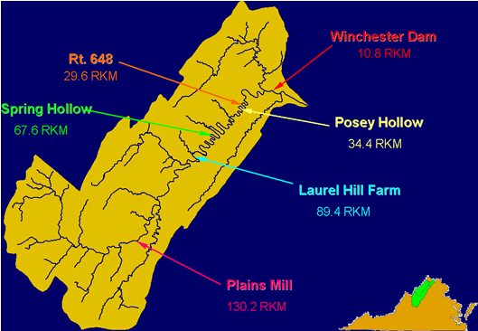
In June 2000, based on the work of Ruhl and Hayes, we (VT & USGS) chose 6 study reaches (with a total of 36 transects) that characterize the mesohabitats (riffle, run, pool, and pocket run) of the North Fork Shenandoah River. We feel these are the minimum number of sites needed to characterize the physical stream.

For photos of each study reach, please visit the following links:
Donald Hayes and Jennifer Krstolic completed the habitat survey from Cootes Store to the confluence of Stony Creek in November 2001. To date, 155.15 rkm of the North Fork Shenandoah River have been inventoried and mapped. Based on this additional data, the mesohabitat distribution in the North Fork Shenandoah River from Cootes Store to the confluence of Passage Creek is: 68.5% runs (61.6% run, 6.9% pocket run), 17.4% pools, and 12.1% riffles.